
The Columbia River is one of the longest rivers in the United States.
Like any river, it is ecologically inseparable from its watershed and basin. A watershed is the land area that delivers runoff, sediment, and dissolved substances to a river and its tributaries.
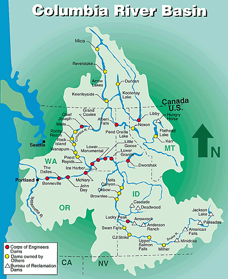
The Columbia Basin spans seven states and one Canadian province. The northernmost reach of the basin is found in the high glaciers of the Canadian Rockies. From there, the main body (or stem) of the Columbia River runs over a thousand miles before passing Portland, Oregon and reaching the Pacific. The Columbia River and its tributaries account for about 219,000 square miles of drainage in seven western states, making it almost the size of Texas.
There are more than 250 reservoirs and around 150 hydroelectric projects in the basin, including 18 mainstem dams on the Columbia and its main tributary, the Snake River. These reservoirs provide 44 million acre-feet of water that can be stored for the purpose of flood control.
In years with lots of rain or snow, flooding in low lying areas and the lower river, especially near Portland, would be common without flood control. To meet this need, Grand Coulee is one of the dams on the American side of the Columbia River with reservoir capacity sufficient to help prevent flooding. By making up to 5-million-acre feet of reservoir space available for flood control, Lake Roosevelt provides the primary U.S. water storage.
On the Canadian side, 3 dams and reservoirs assist with flood control. Specifically, under terms of the Columbia River Treaty, 8.95-million-acre feet (MAF) of water (reservoir) storage was made available to support U.S. flood control needs until September 2024. This is being reduced to 3.6 MAF as part of an Agreement in Principle that is the foundation for a modernized Columbia River Treaty. Click here for updates.
The importance of reservoir storage and coordinated flood control operation was fully demonstrated in February 1996. Heavy rains and melting snow pack due to mild temperatures created the worst flooding in over 30 years in the Northwest. Government agencies and non-federal hydro operators worked together to reduce flood damage by an estimated 3.2 billion dollars. Because the Northwest had a flood control plan in place, the evening news did not show downtown Portland six feet deep in water.
In an average year, a year with 100 percent of normal precipitation, Lake Roosevelt is lowered about 50 feet in April and May to insure against downstream flooding of communities and property. The Corps, by federal law and through a formal agreement with the Bureau of Reclamation, sets the elevation of Lake Roosevelt based on daily, weekly and monthly forecasts. Statistical models, weather reports, runoff information and interagency cooperation are all used to create forecasts and manage lake levels for flood control purposes.