


Ice Age Floods National Geologic Trail begins to take shape
- Details
- Published: Wednesday, 17 December 2014 02:15
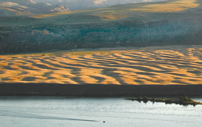
Much of the Northwest’s natural DNA traces back to the end of the last Ice Age, some 12,000 to 17,000 years ago. Our landscapes still bear the markings of cataclysmic floods released from Glacial Lake Missoula, a body of water as large as some of the USA’s Great Lakes.
As waters broke through a lobe of the Canadian ice sheet, a debris field covering 16,000 square miles was left in parts of Montana, Idaho, Washington and Oregon. To the naked eye, you can see high water lines, dunes, massive boulders in the middle of farm fields, giant coulees, dry falls, gravel bars, scablands, and more. For those meandering through these landscapes, “What’s that?” is a common phrase.
 Thanks to legislation enacted by Congress in 2009, public and private partners are collaborating to tell the story by developing the Ice Age Floods National Geologic Trail. Coordinating this effort are staff from the Lake Roosevelt National Recreation Area (LRNA).
Said Dan Foster, LRNA’s superintendent, “We’re turning things upside down a little bit. Commonly, trails tell the story of people and events, tying them to the natural history and landscape of the area. But this is first and foremost a geologic trail with culture and events being told through that prism.”
Partners include Department of Interior agencies, the U.S. Army Corps of Engineers, the U.S. Department of Agriculture, state agencies, Indian tribes, the Ice Age Flood Institute and local stakeholders.
Project Scope
What’s currently envisioned is a trail that is 1,600 miles long. Interpretive signage will provide connective tissue that can be accessed via roadways and various loops and spurs. Some places will be as easy to see and access as getting out of your vehicle, while others will be walks and hikes.
Interpretive themes will include the geologic setting; contemplating cataclysmic vs. incremental changes; distinguishing between easily seen vs. subtle changes etched into the landscape; efforts to continue to unravel mysteries that continue to this day; and the cultural and human history relating to the landscapes.
The guidance for bringing the vision to reality is laid out in a 35 plus page “Foundation Statement” that was finalized in July, 2012. Said Denise Bausch, Chief of Resource Education for LRNA, “It’s like trying to open a time capsule for folks, but it can’t be understood by standing in one place or being an expert in one thing. For those traveling the trail, there will be surprises and “oh wow” moments throughout.”
The Foundational Statement can be found at http://www.iafi.org/pdf/nps_foundationstatement.pdf.
Moving Forward
Although the 2009 legislation galvanized the effort, it also came without funding. As such, partners are developing both capacity and looking for funding in multiple places to move things along.
These efforts are now bearing fruit. In addition to the Foundation Statement, $76,000 of funding has been secured for a firm to develop a long range interpretive plan for trail. Said Bausch, “We’re hoping to develop that plan over the next eighteen months. This will include meetings with stakeholders to get their input.”
And while this is occurring LRNA has hired Colin Bloom, a geoscientist who will develop a transportation plan for the trail. This will include things like identifying major trail geological features, available roads, loops and hiking opportunities, signing needs from both a transportation and interpretive perspective, and ways to tie in with existing resources.
For Colin, peering into the past will provide an interesting contrast to his previous job, where he worked on a team tasked with characterizing the geology and safety of prospective InSight landing sites on Mars.
To participate in stakeholder meetings or continue to get project updates, e-mail Denise Bausch at denise_bausch@nps.gov.